Gotta get those laps in XD
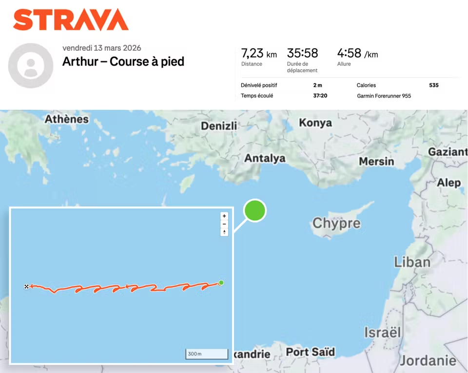
Merde! Macron’s bodyguards reveal his location by sharing Strava data
An investigation by Le Monde has shown that members of the Security Group for the Presidency of the Republic (GSPR) have been openly displaying their location on the popular software during their workout sessions.
https://www.theregister.com/2024/10/29/macron_location_strava/
will they learn one day?
Its kinda the best way to make politicians care about privacy. Make them feel watched by the big brother they’re trying to implement
Unfortunately, this usually just means they find a way to exempt themselves and still support the data collection
OsmAnd ftw
As funny as that is, something tells me it’s not that hard to spot an aircraft carrier in the Mediterranean
You have to be in visual range, or radar range if you have one, which is the horizon plus a bit more depending how high above sea level your are and how tall your target is.
If you’re on a ship, unless you’re using an advanced radar that bounces signals against the ionosphere or you have a meteorological phenomena called an inversion which can curve your radar energy over the horizon a little bit, your radar horizon is surprisingly short, something around 12 nautical miles give or take. And the sea is big and Iran is quite far.
This is one big reason why aircraft are used for surveillance at sea. They can go much higher than any ship’s radar antenna mast every could be which significantly expands their radar horizon. They can also scan a huge area relatively quickly as they can travel much faster.
Because if this fuck up, Iran now has the intel that the French carrier is approaching without even having to send an aircraft out to look for it. If they even still have the ability to do so at this point.
Because if this fuck up, Iran now has the intel that the French carrier is approaching without even having to send an aircraft out to look for it.
It wasn’t exactly a secret, France publicly announced it was being moved to the eastern med
why don’t ships at sea simply disguise themselves as a rock or shrubbery?
Or as a duck if they need to move.
BTW sweden have some cool ship disguises.
Edit: went looking for it, couldn’t even find a photo.
Yeah, that’s how good they are.
Good idea, you should sketch it up in paint and post it to NCD
So satellites can see my truck’s plate but an aircraft carrier and it’s escrow fleet are too… Small?
Sort of. Satellite resources are surprisingly scarce, so a lot are focused where people are, i.e. land. Plus, for the imagery sats that are focused on the ocean, ships are also tiny in a literal ocean of blue. It’s just a spec. While the resolution could be good, have fun looking for that spec. That’s why most countries use signal collection to locate vessels at sea. (I’m over-simplifying a lot, but you get the picture)
While the resolution could be good, have fun looking for that spec.
Seems like an easy but tedious job. Something that a computer can do.
Object detection algorithms are incredibly fast and can learn to tell the difference between an aircraft carrier and an ocean.
There are a surprising amount of false positives when using object detection on maritime imagery. While a carrier is a spec, there are a ton of specs in the ocean that can look similar enough. Plus, weather has a huge hand to play. If it were always perfectly clear, then it’s an easier problem, but one cloud can really mess up the detection. Ultimately, ship detection is a difficult problem (not intractable but still hard).
False positives are fine, you assign 1, 10, 50, 100 analysts to review hits. You only need to find it once, then the search area becomes incredibly small for each subsequent satellite pass.
I’m not saying that it is easy, just that you don’t need to have a surface ship within 15 nm in order to see it.
I’m not saying that it is easy
It kind of sounds like you’re saying that. Anyways, there’s a reason submarines exist
It depends a great deal on if you have access to a real-time satellite feed and know where to look.
It’s the ocean. The majority of Earths surface where there’s usually not much going on
You still need to know where to point that spy satellite’s camera at. If you take picture that covers hundreds of square kilometers then you don’t have enough resolution to spot the ship but you can’t zoom in much either because you don’t know where to zoom.
It’s different with buildings because you know where they are.
China and Russia could also just tell Iran, if they don’t have satellites of their own
I saw the location on one of those “war dashboards” a day or two ago. Can’t have been that secret.
Apparently strava is for posting your runs on social
That sailor now got the runs
must have been a bomb run
Eyoooo
Same thing happen with unlisted FOBs in Afghanistan and the U.S. army. running apps have compromised opsec of a surprising amount of facilities.
I remember reading that. My brother is in the AF, and through some system, they can get gear like Garmin Fenix watches that does GPS tracking and uploads to their cloud and can be synced with Strava. It’s wild that stuff like this isn’t strictly monitored to prevent this exact scenario.
And here we are, fifteen years later.
Imagine losing a carrier cuz one of the soldiers forgot to read the privacy notice on their smartwatch
Imagine losing a carrier because a major world power’s military IT security is so incompetent they’re allowing sailors on active deployment to have unfettered internet access.
There was a similar incident where they found a sailor on one US Navy ship had their own Starlink terminal because they were broadcasting an SSID. At the end of the day, you can’t fix stupid.
One of the early successes of Russia’s invasion of Ukraine was when they took out a barracks of foreign volunteers because around 40 of them were ex-british soldiers and Russian intelligence linked their phones to historical records collected outside British army bases.
I think this is more of a consequence that the things one buys now aren’t only serving their paying customers interest
Why is it zig zagging?
that’s how it looks when you walk/run in circles in a vessel that’s moving
Wow. Can you infer vessel speed by assuming the run always concluded at the start position? The bottom line doesn’t meet back at the top line because the ship and runner were going in opposite directions.
You don’t need that assumption. Your assumption can just be “the person and vessel (or a point in the vessel, like its center of mass) don’t diverge significantly over time”.
Then, if you treat velocity as a vector and compute the person’s average velocity vector over time, you’ll have a pretty close estimation to the vessel’s velocity vector.
After all, if those two average vectors (vessel’s and person’s) were to differ much, they would end up in different locations.
The average basically zeroes the vector for each lap the person does, so the remainder must be the vessel’s.
He’s running up and down the deck
iambic heptameter ass route
Removed by mod